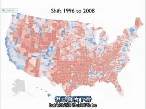
This is,oh,bishop
接下來的是Bishop(意為主教)縣
We know Bishop is in Europe, right?
我們都知道大主教在歐洲對不?(玩笑)
Anyway, it's a place that's of small population
言歸正傳 Bishop市的人口很少
Bishop and a lot of people have moved there from the places like bay area
很多Bishop的人口是從舊金山灣地區移居過去的
For it's natural amenities
是因為那里有宜人的自然環境
So, you see very different voting patterns
所以你發現那里的選民投票傾向不一致
but it changes because of that
是因為受到移入者的影響
And when you get a real small of population
當一個選區人口很少的時候
You don't have to have a huge influx of people to really switch it over
即使沒有大量的遷入者,他們的支持傾向也很容易改變
yes, the question is why you have the blue counties Democratic voting counties
現在的問題是為什么有這么多藍色的民主黨支持縣
here along in Nevada broader
分布在加州和內華達州交界
and it would be Mono county and Alpine county
那是Mono縣和Alpine縣
With transplants from the bay area
這里有很多來自舊金山灣的移民
would the biggest reason for that
因此他們傾向民主黨
California if you think it's extreme
如果你認為加州是分化極為嚴重的州
take a look at Pennsylvania
那我們不妨來看看賓夕法尼亞
James, Democratic strategist had an interesting observation about Pennsylvania
民主黨政治家James曾對該州做過一個十分有趣的形容
Maybe you've heard it
你可能已經聽說過
If you from Pennsylvania maybe you'll be offended
如果你來自賓夕法尼亞,你可能會覺得這個形容有點冒犯

but his lying was, yes, Pennsylvania
他說,賓夕法尼亞
You have Philadelphia at one side, Pittsburg on the other
除了東邊的費城和西邊的匹茲堡
and Alabama in the middle
中間就像是一個活生生的阿拉巴馬州
not entirely but in voting patterns oh, you bet
不是在所有方面但在投票傾向上的確神似,毫無疑問
Many of these counties in central Pennsylvania extremely Republican voting
大部分賓州中部的縣都是極端的共和黨支持者
So we have very much a divided state
所以這個州比加州的分化情況還要嚴重
California and Pennsylvania are by no means the only one
而這種分化絕不僅僅出現在加州和賓州
Oregon,Washington very big gap New York as well
俄勒岡州華盛頓州都有著嚴重的傾向分歧,連紐約也不能幸免
the only part of the country
美國唯一一個
While you'll see most counties voting for the Democratic party would be New England
幾乎所有縣都支持民主黨的地區,是新英格蘭
Elsewhere most counties, oh, Hawaii too
以及夏威夷
Elsewhere most counties are going to be voting for the Republican
其他地區的大部分縣都支持共和黨
Yes? absolutely so, what do we do?
請提問?當然是的
The question is you just point out population density
他的問題是,剛才我提出了人口密度的問題
So then what we need to do is show maps that take that into account
我們是否也應該研究一些考慮了人口密度因素的地圖?
and I have some in store
我的資料里存了很多這樣的地圖
So that'll be coming soon
等會兒就會給你們看的
One another thing that Republican partisans might want to say is
共和黨人會提出的另外一個建議
Ok, let's take the whole country
讓我們看看各州的
and look at the county level patterns
縣級選情地圖
Look at the vote, what we see?
現在你們看到了一個怎樣的景象?
We see a red country with blue splotches
我們看到了一個紅色的國家散布著藍色的斑點
We see some splotches in the center
我們看到中間一些藍色的斑點
It's interesting, these blue areas of the south
分布在南部的藍色,有點特殊
and I don't have the map now
我現在沒有地圖
but I'll show it to you later on correlates almost exactly with racial patterns
等會會找給你們看,南部的藍色和人種分布有很大的關系
heavily African-American counties along the Mississippi
有大量非洲裔聚居的縣分布在密西西比邊沿
and what's known as the black belt of Alabama
這就是人們所說的阿拉巴馬的黑人地帶
and parts of the XXX of Virginia as well
它還包括弗吉尼亞的部分地區
By in large though, you look at that map and what do you see
從大體上說,我們看到這幅地圖時會有什么印象呢?
You see a lot of red and not that much blue
你會看到大片的紅色和較少的藍色
If we map it a little more carefully
如果我們更加細致地來繪制這幅地圖
to show percentages in various colors
可以用不同的顏色深淺來表示百分比
If you go to Dave Leip's Atlas
如果你去看Dave Leip's Atlas
you can see the color differential very clearly on this it doesn't show up
那里顯示的地圖,顏色區分度會更明顯,這幅地圖上的顏色區分有點模糊


