Oceanic cartography
繪制海洋地圖
Full fathom five
海神的召喚
How to map the seabed from the sky
如何從空中繪制海底地圖
An alien seeking a name for the third planet from the sun might reasonably plump for "Sea" or "Ocean", rather than "Earth". Two-thirds of its surface is covered by salt water, and its predominant colour, viewed from far away in space, is blue. What underlies all this brine, though, remains surprisingly mysterious to the planet's ape-descended inhabitants. As recently as 2019, for example, researchers found several thousand new underwater mountains, known as seamounts, by measuring the effects of their gravity on the ocean's surface. More such discoveries almost certainly await.
外星人在為太陽(yáng)外的第三顆行星命名時(shí)可能會(huì)選擇“Sea”或“Ocean”,而不是“Earth”。因?yàn)樗谋砻嬗腥种缓K采w,從太空遠(yuǎn)處望過(guò)去它的主色是藍(lán)色。然而,對(duì)于生活在這個(gè)星球上由猿類進(jìn)化而來(lái)的居民來(lái)說(shuō),這些海水的背后仍然是個(gè)謎。例如,就在2019年,研究人員通過(guò)測(cè)量海洋表面重力的影響發(fā)現(xiàn)了數(shù)千座新的水下山脈,即所謂的海山。幾乎可以肯定的是,有更多這樣的發(fā)現(xiàn)在向我們招手。
One important reason for ignorance about the seabed is the lack of a tool that can easily map its topography from an aircraft flying above the water. That, though, is about to change. Researchers at Stanford University, led by Amin Arbabian, an electrical engineer, have developed what they call the Photoacoustic Airborne Sonar System, PASS. This makes it possible to scan the ocean floor rapidly, from a helicopter, rather than relying on a slow-moving ship or submarine.
海床被忽視的一個(gè)重要原因是:人們?nèi)狈σ环N可以在水上飛行的飛機(jī)上繪制出海床地形的工具。不過(guò),這種情況即將改變。在電子工程師阿敏·阿巴比亞的帶領(lǐng)下,斯坦福大學(xué)的研究人員已經(jīng)開(kāi)發(fā)出了他們所謂的光聲機(jī)載聲納系統(tǒng)PASS,使得從直升機(jī)上快速掃描海底而非依靠緩慢移動(dòng)的船只或潛艇成為可能。

The problem to be solved is that sound waves, in the form of sonar, are the only reasonable way to accomplish such mapping. Both light beams and the radio waves of radar are rapidly absorbed by water. Sound, by contrast, propagates well. What it does not do well is cross the boundary between water and air. When this happens its amplitude is diminished a millionfold. That diminution applies in both directions, so a pulse of sonar broadcast from an aircraft and reflected back to it from the sea floor would have a trillionth of its original amplitude. Expecting to detect such a reflection would be a fool's errand.
需要解決的問(wèn)題是,聲納形式的聲波是完成這種測(cè)繪的唯一合理方式,光束和雷達(dá)的無(wú)線電波都會(huì)被水迅速吸收,相比之下聲音傳播的效果會(huì)更好,它的缺點(diǎn)是無(wú)法很好地跨越水和空氣之間的邊界,這種情況下它的振幅會(huì)減小一百萬(wàn)倍,這種減小會(huì)發(fā)生在來(lái)往兩個(gè)過(guò)程中,所以從飛機(jī)發(fā)出的聲納脈沖再?gòu)暮5追瓷浠仫w機(jī)時(shí)其振幅只有原來(lái)的萬(wàn)億分之一,因此期望探測(cè)到這樣的反射是徒勞的。
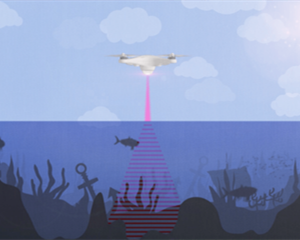
PASS partly overcomes the air-sea boundary problem by circumventing the first of those crossings. It does so by generating the sonar pulses not on board the aircraft but rather in the water itself, using intense bursts of laser light fired at the water's surface. These heat the water, causing rapid expansion. That generates a sound wave which propagates to the sea floor, whence it is reflected back to the surface. Only then does it cross the energysapping interface between water and air. Though that still weakens the signal a lot, the other part of PASS, a device called a CMUT, is sensitive enough to detect it.
PASS通過(guò)繞過(guò)第一個(gè)交叉點(diǎn)克服了海空的邊界問(wèn)題。它并不是在飛機(jī)上產(chǎn)生聲納脈沖,而是用強(qiáng)烈的激光射向水面從而在水里產(chǎn)生聲納脈沖,使得海水變熱,迅速膨脹。之后產(chǎn)生聲波,聲波傳播到海底,然后又反射回海面,只有這樣聲波才能穿過(guò)水和空氣之間的能量消耗邊界。盡管信號(hào)仍會(huì)被大大削弱,但PASS的另外一部分(一種叫做CMUT的設(shè)備)已經(jīng)足夠靈敏,完全可以檢測(cè)到信號(hào)。
譯文由可可原創(chuàng),僅供學(xué)習(xí)交流使用,未經(jīng)許可請(qǐng)勿轉(zhuǎn)載。


