Xidi and Hongcun——Ancient Villages in Southern Anhui
皖南古村落—西遞村與宏村
自然概況
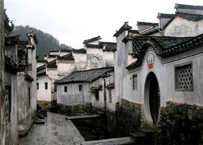
Xidi village is 8 km east of the town seat of Yi County,Huangshan City,Anhui Province. According to“Noble clans in Xin'an”,the place was surrounded by“Mt Luo in front,Mt Yangjian at the back,Mt Shishi in the north,and Mt Tianma in the south,flanked by two rivers flowing to the west instead of the east,hence named as Xidi",which means“passing to the west" in Chinese.
西遞村位于安徽省黃山市黟縣城東8公里處,根據《新安民族志》記:“只地羅峰高其前,陽尖障其后,石獅盤其北,天馬靄其南。中有二水環繞,不之東而之西,故名西遞。”即取水勢東往西流之意。

The village embraced in the mountains is really scenic and abundant of resources. Inhabitants here are accustomed to a life of leisure and self-reliance with little disturbance from outside,therefore keep much of their ancient customs and enjoy the fame as“lucky folks of an Utopian land".
西遞村群山環繞,景色優美,物產豐富。這里的人們習慣于過自給自足、怡然自樂的生活,受外來影響較少,因而使得不少古風俗都仍然保留至今,被譽為“桃花源里人家”。
The present Xidi village occupies an area of 12. 96 hectares surrounded by mountains,with three rivers or streams running throung from the east and north to join into one in the south of the village. One main street and the two waterside roads provide the main structure of its streets and lanes roughly from west to east,expanding to the north and south at the same time,all paved with local stone slabs. The lanes,the streams,and the houses are pleasantly integrated with a rhythmic variation of space. The ancient buildings are mainly of brick and log、decorated with a variety of wood,stone and brick carvings impressively plain and elegant,characteristic of the talent and achievement of the ancient villages in the creating of human residence in southern Anhui.
如今的西遞,整個利落向積為12.96公頃,四面環山,有三條溪流從村北、村東流經全村。村落以一條縱向街道和兩條沿澳道路為主要骨架,構成以東向為主,向南北延伸的村落街巷系統所有街卷都是采川本地產的青石鋪地。巷道、溪流、建筑布局相宜,村落空間變化富有韻律感。古建筑多為磚木結構,用豐富多彩的木雕、石雕、磚雕作裝飾,色調樸素淡雅,大方怡人,體現獷皖南古村落在人居環境營造方而的杰出才能。

Hongcun village lies at the southwest foot of Yellow Mountain(Huangshan),11 km southwest of Yi County,a gateway for merchants to go to the capital city in ancient times.
宏村位于安徽省黃山的西南麓,黔縣城西南11公里處,原是古代黔縣赴京通商的必經之路。
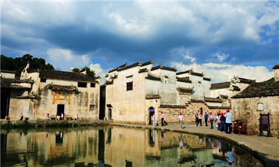
The village covers ?8 hectares,of which 19.1 l are recognized as the ancient village, where there are 158 folk houses of Ming and Qing Dynasties and 137 of them are preserved intact. With its main street as the axis,the village is near the joint of Yangzhan River and Sui Stream in the west,East Stream and East Mountain in the east,Leigang Mountain at its back,Moon Pond in the north,South Lake and Qishu Lake in the south.
宏村占地約28公頃,其中被界定為古村落范圍的面積有19. 11公頃村落里現存有明清時期修建的民居158幢,其中的137幢保存完整整個宏村以正街為軸線,西臨羊棧河、灘溪交匯處,東傍東溪和東山,背靠雷崗山,北圍月塘,南倚南湖和奇墅湖。
The layout of the village resembles theoutline of an ox,hence it is popularly addressed as“Ox-shaped Village".The high Leigang Mountain is the perking head,the tall green trees are the horns,the villoge proper with its crowded houses is the body,the clean ponds are the stomach,the meandering ditches among the houses are the intestines,and the four outthrust bridges are the legs. The village,then,lies peacefully like an ox at ease among the blessing green mountains guarding the fertile farmlands.
宏村整個村落布局猶如牛形,故又被人們稱為“牛形村”全村以高昂挺拔的雷崗山為“牛頭”;滿山青翠蒼郁的占樹是月的“頭角”;村內鱗次櫛比的建筑群是“牛身”;碧波蕩漾的塘湖為“牛胃”和“牛川‘’;穿堂繞屋、九曲十彎的人工水圳是“牛腸”;村邊的四座木橋為“牛腿”:宏村就似頭臥牛處于青山環繞、稻田連綿的山岡之中。


