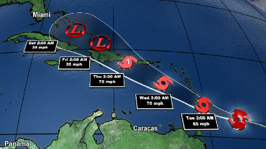
JUDY WOODRUFF: Hurricane Dorian is threatening to bear down on Florida by Monday, prompting residents there to start stocking up on bottled water, gas and other supplies. But the Category 1 hurricane's precise path is hard to predict. Dorian veered towards the Virgin Islands, drenching them with heavy rain and whipping winds, but then largely missed Puerto Rico. Ken Graham is the director of the National Hurricane Center in Miami, and he joins us now for an update. Ken Graham, welcome back to the NewsHour. First of all, tell us what you know right now about Dorian.
KEN GRAHAM, Director, National Hurricane Center: Every indication is continuing to get stronger. We're looking at this structure very closely, getting aircraft out there, studying this 24 hours a day. And getting stronger is exactly what we're forecasting, continuing to get stronger with time, just a lot of warm water, not a lot of shear, and then not a lot of interaction with terrain as well. So it's going to keep getting stronger. And we're forecasting to become a major hurricane,even a Category 4-strength, 130 miles an hour, as we approach the Florida coast, so a big event, a lot of uncertainty in the forecast. That center could be anywhere in that cone.
JUDY WOODRUFF: And, Ken, you say a lot of uncertainty. What is going to determine the exact path and the strength of this storm?

KEN GRAHAM: Yes, so many factors going on here. In this case, we have, this ridge of high pressure.It's out here. It almost acts like a bubble. So, when the storm moves forward, it hits that bubble. So the stronger that high pressure is, then we're going to have a quicker turn. If it's a little weaker, it's going to be wait a little bit longer. And that will be the northern track. So we're really trying to understand how strong that is. And that's why we're seeing the models change a little bit. And that's why we have a comb, because, with that uncertainty, it could be anywhere in there. So the message is anyone along the in Florida, along the coast, and also inland has to be ready.
JUDY WOODRUFF: Do you have a sense of when we're going to know better where it's hitting?
KEN GRAHAM: You know, I think really when we start seeing that turn. I think this is one of those situations that, as we move towards the northwest, we start seeing that turn more towards the west. I think, if you think about, with time after that happens, you can extrapolate from there, and that, we're going to have a better idea. So, in the next few days, I think we will have a better handle on it. But either way, no matter where that track goes, no matter where the center is, Florida will be impacted by rain, storm surge, the winds, just a big impact event.
JUDY WOODRUFF: So the advice then to people who live anywhere in that bubble area you have at the end is to do what?
KEN GRAHAM: It is to be ready, because, if you think about it, it's interesting. We have plotted the arrival of the tropical-storm-force winds. So, no matter the exact track, no matter where the center is, you will start seeing tropical-storm-force winds reach the coastline, here's Florida, probably late on Sunday, by 8:00 p.m. or so moving onshore.
So the winds are coming. The rain is coming. The storm surge is coming. So it's time to be prepared and listen for the latest information, and especially listen to those local officials.
JUDY WOODRUFF: Well, we will certainly do everything we can to get the word out.Ken Graham with the National Hurricane Center, thank you.
KEN GRAHAM: You bet.


