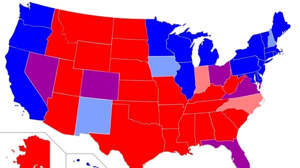
It is commonly portrayed as a polarity that is starkly structured on spatial lines
我們常把分化嚴重的區域用空間直線來進行劃分
With what I sometimes called the map the map of Red and Blue America
從而形成我們所看見的地圖,這幅紅藍地圖
A map that looks back at 2004, actually very similar to the one in the 2000 election
反應的是2004年的選情與2000年大選的地圖十分相似
Showing the states that voted for the Democrat candidate in blue
在地圖上,民主黨候選人獲得選票的州用藍色表示
Those for the Republican candidate in red
共和黨候選人獲得選票的則用紅色表示
I'm sure you've all seen this
你們之前肯定都已經看過這幅地圖
But we see one is with a lot of geographical clumping
我們看到很多地理上的聚集現象
We see a continuous swath of red states
我們看到一大片連續的紅色州
And we see the blue states in three different areas
以及分布在不同區域的藍色州

In the north east, New England and middle Atlantic states
這些州分別分布在東北的新英格蘭地區,大西洋沿岸中部地區
and what we may call the upper great lakes and along the pacific coast
以及靠近五大湖區域的右上部和太平洋沿岸
How accurate is this
這幅地圖有多精確呢?
Well, this is something that we're going to be spending a lot of time looking at
我們將會花很多時間來仔細地研究這個問題
And trying to figure out just how much this map tells you
思考我們可以從這幅地圖得到什么信息
It misses a lot you know it misses the county level
它遺漏了很多信息,例如,你無法從中了解縣級的選情
That's something we will go down and we'll look at
這部分內容我們還會再仔細地來探討
One thing, those who tell us that we are experiencing extreme polarization
那些告訴我們分化情況已經非常嚴重的人
Is to look at the county level and to look at the number of so called "landslide counties"
都會以縣級選舉數據中那些"穩贏縣"的個數為依據
Counties where one candidate wins by more than 20%
某縣級選舉中某個候選人贏得超過20%的投票則該縣成為"穩贏縣"
Back in 1976 only some 27% of U.S counties were landslide counties
1976年時只有大約27%的縣是"穩贏縣"
In last selection it more like 48%
上次大選中則有48%的縣為"穩贏縣"
So we've seen a big jump
我們看到這個數字在這些年是在大躍進
But remember this compare that to Ukraine and Bolivia
但你們要記得與烏克蘭和玻利維亞相比
That initial Ukraine map actually all of those counties of electoral districts except for one were landslide
尤其是剛才給你們看的那幅烏克蘭地圖幾乎所有縣級選區,除了一個之外,都是"穩贏縣"
whereas 20 % is not that extreme
相比之下美國的20%則沒那么極端
But it is much more extreme than is was as I say 20 years ago,30 years ago or 40 years ago
但現在的分化情況的確比20年前 30年前或40年前要嚴重
This map is one that, like I say it's deeply penetrated public consciousness
我想這幅地圖大家都已非常熟悉
It's interesting to see how it's portrayed as the objects of a lot of parity
我們來看看它是怎么被描述的也許更有趣,每個圖標都有其對應的含義
Yes, one fish, two fish, red state, blues state
一條魚,兩條魚,紅色州,藍色州
I thought it is interesting that California is much large than Texas in that map
我覺得這里一件很有意思的事情是加州居然被畫得比德州大那么多
May tell you something about the person who made it
你大概可以由此猜測出畫這幅圖的是誰


