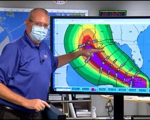
JUDY WOODRUFF: The Gulf Coast is facing a very rough week. Tropical Storm Laura is gaining strength and could be a Category 3 hurricane by the time it makes landfall later this week. It's expected to hit along the coast of Louisiana and Texas, potentially with 100-plus-per-mile hour winds. And, even as we speak, the coast is feeling the effects of Tropical Storm Marco. It's weakened, but is still bringing rain. Ken Graham is the director of the National Hurricane Center. And he joins me now from Miami. Ken Graham, give us a sense of what these storms look like right now.
KEN GRAHAM, Director, National Hurricane Center: Yes, right now, looking at the satellite here, Marco is very close to making landfall right here at the mouth of the Mississippi River. But what is interesting is, most of the rain was sheered off. So, most of the heavy rain is the Southeast U.S. in the Florida Panhandle all the way up into Alabama, Georgia and Carolinas, so heavy rainfall, but we're looking at Laura as well, just a large circulation just south of the island of Cuba. And we expect it to make its way into the Gulf of Mexico and strengthen into a hurricane.
JUDY WOODRUFF: And, Ken Graham, how usual or not is it for two hurricanes…or two storms to be coming so close together like this?
KEN GRAHAM: Yes, it's just…it's very unusual. And it is a situation that it is usual from a meteorological perspective, but it's also unusual and difficult from a preparedness standpoint as well, because you start getting the impacts in certain locations from Marco, and, two days later, you start getting a stronger system. We expect to be a much stronger hurricane when it comes to Laura making its way to the Gulf Coast.
JUDY WOODRUFF: So, how does the first storm, which…as you say, Marco is weakening, but still bringing a lot of rain. How does that affect, complicate or lay the groundwork for the storm that follows it?

KEN GRAHAM: Yes, it's an interesting situation, because that storm was so small, so there wasn't much influence on the temperatures in the Gulf. There wasn't much influence really shaping how Laura reacts as well. So, this is what is going to happen. With time, we get into the Gulf, there is not a lot of sheer. The warm waters of the Gulf, the upper air pattern, everything's coming together for development. Expect that hurricane to make its way north toward the upper Texas coast, to Central Louisiana, get that landfall, however, a larger storm than Marco. So, some of those impacts can stretch well away from the center. You could you see storm surge as far away as the Mississippi coast, maybe even into Alabama, with that landfall even that far west.
JUDY WOODRUFF: And do you fell at this point, Ken Graham, the word is getting out sufficiently to people who could…could be affected by this?
KEN GRAHAM: Yes, we're doing every media interview that we can to get the information out. We're doing briefings. I'm actually out here in operations right now. The hurricane specialists are here on the phone doing briefings. We're doing everything we can to get the word out. But we really need to, because, if you think about it, the arrival of these impacts occur before the center. So, even you start looking at a center that is still in the Gulf, that storm surge, the rain, the wind is well out ahead. So you have today, you have tomorrow, and then all of a sudden, Wednesday, some of these impacts will be felt.
JUDY WOODRUFF: And that is what I wanted to ask you. When…what day are we looking at for maximum impact? You're looking at Wednesday?
KEN GRAHAM: Yes, it looks like Wednesday. So, you see the landfall here. And I wanted to show this here. You start looking at the arrival of the winds, this is actually the arrival of the tropical-storm-force winds. That is a good indicator when you have got to wrap stuff up because it is too dangerous to be outside. So, Wednesday 8:00 a.m., you start seeing some of these winds reach the Southeast Louisiana coastline and during the day Wednesday spread northward. So, Wednesday, you are going to start seeing a whole lot of impacts along the Gulf Coast.
JUDY WOODRUFF: Ken Graham, director of the National Hurricane Center, thank you so much. We appreciate it.
KEN GRAHAM: Thank you.


